I used to be appallingly bad at drinking enough on long walks and suffered from heavy legs, lack of 'oomph' and headaches as a consequence. However, since my brother Dave gave me one of his kidneys I've made a conscious effort to stop all that nonsense and look after myself considerably better. And the difference is quite marked. In the past, the start of Day 2 on a Challenge, even after an evening of rehydration, would see me below par. Today I am absolutely full of beans.
I'm up early, looking forward to our day. Summer early mornings in the Highlands are well worth climbing from your pit to enjoy, albeit if only briefly. This morning it is bitingly cold. Our tents are in deep shadow and a northerly breeze cuts like a knife.

 |
| FROST-SAGGED SIL-NYLON. FRANKLY, I'M AMAZED NO-ONE NICKED PHIL'S POLES. |
Taking a few snaps, within minutes my fingers are aching with cold and so I dive back to the warmth of my bed to prepare breakfast.
 |
| HEAVY FROST OUTSIDE. HOT COFFEE & ORANGE AND BREAKFAST BARS IN BED |
As the sun breaks free from the hills and flares from between the clouds, I'm outside again, snapping away, hoping that my little camera can capture just a smidgen of what is about me. It is stunning out here. An Akto zip is dragged skywards and Phil joins me. We pass the flasks to each other. Full lung inflation is attained. I'll let the pictures tell the story of the next hour or so ~ one of the happiest hours of my Challenge.
 |
| THE HALLELUJAH CHORUS |
 |
| TRINNIE TRAILSTAR IN HER ELEMENT |
 |
| FROST MELT |
 |
| A WARMING MEERKAT |
 |
| BREATH-TAKING |
Reluctantly, we perform our ritual of morning magic, stuffing away our entire life support system into the little bags on our backs. We check the ground fastidiously. No sign of any henge. No naughty nuts or rascally raisins hiding away in the heather.
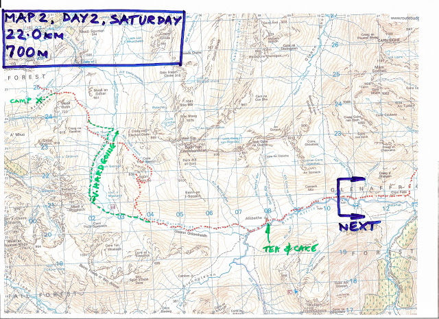
And here we have the maps for today. As before, the red dotted line is our proposed route and the green dots indicate the route taken on the day. Study these carefully, as there will be questions at the end of the class. Again, as before, you can click on any of today's images to make them much larger. Right click on them to open them in a new window or tab so you can blow them up larger still. Got that? Marvelous. Let's continue then...
And here we have the maps for today. As before, the red dotted line is our proposed route and the green dots indicate the route taken on the day. Study these carefully, as there will be questions at the end of the class. Again, as before, you can click on any of today's images to make them much larger. Right click on them to open them in a new window or tab so you can blow them up larger still. Got that? Marvelous. Let's continue then...
And we're off. We head off to collect the blazed path that cuts through Bealach na Sroine, scamper along it and then... And then we find the most perfect of paths.
She is marked on the map, curving around the bulk of Meall Dubh on a sharp break of slope. The OS says it lasts about a third of a mile. Here she is below, in all her finery, just after we have joined her. She rises gently and lets you enjoy her sinuous curves. This is no beaten path; This little beauty has been built with love and care. Once in awhile, the slope above engulfs the narrow trod, but it takes little effort to pick her up again a few yards later.


 |
| WE 'TOOK THE ONE LESS TRAVELLED.' BEALACH NA SROINE |
You're never in doubt as to where she is headed - that little break of slope - those stepping stones way over there - that large boulder. I have followed these girls all over the Highlands, as far south as Oban and as north as Cape Wrath. They are built with poor weather in mind - you will be safe if you stay with them. You almost imagine your way along them. And sure enough we follow her for a mile and half, safely down through the lateral moraines and down into the vast bottom of Gleann Gaorsaic.
 |
| ROUNDING THE HILL AND THEN THROUGH THE MORAINES |
 |
| DROPPING INTO GLEANN GAORSAIC |
It will be a huge loss when these paths are no longer walked. Already the mapping only shows where paths are clearly defined on the ground, but soon they will be gone. They were built for purposes other than walking across Scotland. In some cases they were clan paths, linking the glens together. In others they were for stalking. But whatever their purpose in the past, it's dreadfully sad that nature is taking them back as they offer some of the best walking and views that the Highlands have to offer.
For your next TGO Challenge, take a good look at the map for some of these stub-paths. Follow them and you'll follow hundreds of years of history, and for a lot further than the Survey would suggest.
 |
| BEINN FHADA FROM THE VASTNESS OF GLEANN GAORSAIC |
We reach the comforting bottom of the vast Gleann Gaorsaic and have a very long, leisurely break, utterly pleased as punch with ourselves. One hundred percent Smug Mode. The glen has a reputation for ghastly sodden trudges through tormenting tussock - this is my fourth visit and I have to say it is at its finest. The recent dry spell allows for slightly better than the usual stumble. Not much, mind.
As we lie here we watch a couple of Challengers on the far side of the glen work their way along. Sadly, they seem to be about fifty feet or so above the line of a faint path that we can see with all the advantages from our position, but they cannot. However they fairly scamper along and we don't see them again. After about an hour or so (we are avoiding eye contact) I begin to wonder if Phil is ready to move. I'm certainly not. It's wonderful slobbing about doing sod-all in this magnificent spot.
 |
| CHALLENGERS CROSSING ALLT THUILL EASAICH, GLEANN GAORSAIC |
Phil must be a bit of a mind-reader, as he doesn't look like he wants to move either. Ignoring each other for as long as possible, it slowly dawns on us that those Challengers disappeared from view absolutely ages ago, and they had started their progress up the glen from way behind us... Oh God. We both stir simultaneously, quite shocked that the other is also packing the remains of elevenses away as well. And so we march off once again. We take a look at crossing the river but it's deep and wide here and so simultaneously we both say "You know, I think we'll do that Corbett another time."
 |
| PHIL. LOOKING NORTH DOWN GLEANN GAORSAIC |
We decide we'll have a slow plod up the western side of the glen; the eastern side being the usual route if you're heading to Alltbeithe. It is quite tough going in places, with wonderful gloopy sections and a few clambers in and out of tricky peat bogs. In fact it's very hard work for this pair of slack-packers. The great views are those behind you to the north. Phil acts as a bit of foreground interest and I direct him either left or right to make a better composed photograph. I'm not sure that he enjoyed this...
 |
| LOCH A BHEALAICH, GLEANN GAORSAIC |
 |
| SIMPLY GLORIOUS |
I hope that you too agree that this is utterly fabulous. Go there. Make a resolution right now to see this place. You may curse me for the bog and perhaps a few blisters, but you will send me love and sweet thoughts for ever-more for the glorious experience of this beautiful wild place.
 |
| ALLTBEITHE YOUTH HOSTEL & GLEN AFFRIC, FROM GLEANN GNIOMHAIDH |
Happily, the bloody hard work of the bog trotting comes to an end as we collect the path down from Bealach an Sgairne. And now we absolutely whizz along and before you can say "Daa-aad, how much further is it?" you are staring down at the oasis that is Alltbeithe. That is, after Phil has made a rather nice cup of tea in Gleann Gniomhaidh and we snooze for a while in the sunshine... This is my kind of walking!
 |
| FULL OF TEA & CAKE, LEAVING ALLTBEITHE, GLEN AFFRIC |
 |
| PHIL, LOCH COULAVIE, GLEN AFFRIC |
Taking the northern track around Loch Affric (by far and away the most scenic route down the glen!) we come across the Allt Coulavie cutting across our path quite late in the afternoon. We're not far from our intended camping spot. Phil boulder hops across the quite lively and bouncy burn and I attempt to follow him. I have no idea why, but I thought I was following his line when I just could not work out how on earth I was to get from this to that rock without hopping from one foot to the same foot midst leap. I was completely nonplussed, and stand there like a twat trying to work out how to do it. To slip now would be pretty ghastly. Phil stares at me patiently, occasionally proffering help, but I realise I'm a hopeless case, and retreat to the bank I had started from, walk back down to the track's ford and change into my river crossing shoes.
By the time I'm back in my walking shoes we must be a good twenty minutes later into the now early evening. Whoops!
 |
| CORRIMONY WIND FARM, LOCH AFFRIC |
And then we turn to carry on. Phil notices them first. To our complete horror we notice the Corrimony wind turbines flailing away, caught in the early evening sunlight on the far side of Loch Affric.
Glen Affric is a National Scenic Area and Highland Council allowed this desecration to take place. The members who allowed this excrescence to be built, the landowner who trousered millions of pounds for the ground rents and the local community who actually supported the planning application (for they were also to trouser community bribes and, I understand, a small share of the profits) should each be named and shamed. I want to know who each and every one of them is, so I can place their photographs in the public car parks in Glen Affric so that the thousands and thousands of visitors who come here every year - some from the far flung corners of the globe, can spit in their eye and hate them as much as I do. They disgust me.
 |
| CORRIMONY WIND FARM |
Moving swiftly on, as it is becoming a little later than we expected, we drop down the side of a rushing burn, quite a way from the track all the way down to the shore of Loch Affric. It involves a little bush-whacking in places but my word it is worth it! We camp on a a little delta formed by Allt Coire Leachavie and so we are set up with Loch Affric to either side of us, with ancient Caledonian Pines behind and the loch stretching away to our front. We sleep on nibbled soft turf. The gentle breeze keeps all the bitey things at bay. All in all, it is utterly perfect.
 |
| PERFECT PITCH |
That's two nights in a row now. We're getting the hang of this backpacking lark. Good night, Campers!
 |
| EVENING, GLEN AFFRIC |
Saw the turbines when we were there and they spoil so much. There are plans for more at Beinn Mhor, just to the north west. The hydro schemes as well, through Glen Cannich are also changing the views and i was shocked to see so much heavy plant and new road coming down from Liatrie burn to the single track glen road and also on the north end of Mullardoch dam where another scheme is underway on Allt Taige.
ReplyDeleteHowever you picked, sorry Phil picked a good route through and it was worth all the effort as the photos show. Did you miss off day 2 map for a reason?
Hi Al.
DeleteI wrote about Beinn Mhor a while ago (HERE and you'll be very pleased to hear that it was kicked out by the reporter in December of last year.
There was MASSIVE local resistance to it, and a hugely successful campaign to stop WPD - the developer - in their despicable tracks.
And yes, you're right - there are loads of small hydro schemes underway, all with their inevitable haul roads - huge scars on the landscape. None would be built if it wasn't for the very heavy subsidies. It's snouts in the trough, as per usual.
The Map for Day 2 - to be honest I finished this post at about 11:30 last night and clean forgot about the map. I'll cobble one together later this evening, Sir and include it in the post. I don't like reading about great routes unless I can flick back and forth to a map either!
Thanks for taking the time, Al - it's appreciated.
:-)
Here you go, Al.
DeleteMaps now included Sir.
Thanks for the nudge!
:-)
Super first couple of days!
ReplyDeleteWe felt we had to keep pinching ourselves as it was so good, And we didn't give a monkey's about missing the Corbett as we reckoned we worked much harder slogging our way throught Gleann Gaorsaic!
DeleteThe wonderful thing about our route for the second day is that it is fabulous even on dreadful weather (I've done it in awful weather the once) and tea and cake from the wonderful Hanne at Alltbeithe is icing on the cake... :-)
Our stravaig would probably have been a lot easier up to the 19th century, when the highlands were populated and a lively commerce in cattle was carried on along with a degree of modest agriculture. Not only were the lost paths regular highways, but they were maintained - for example the Larig Ghru was cleared of fallen rocks and boulders after each winter to allow free passage.
ReplyDeleteIt may not seem like a very good valley for droving but that is because until droving died out local people were paid to go into the Cairngorm glens and clear the boulders to the side, a practice clearly no longer followed. The Lairig Ghru is said to have been used for droving until about 1873. Source: Heritage Paths Project, ScotWays, Scottish Rights of Way and Access Society.
Now some walkers seem to revel in traversing the most appalling boggy and boulder strewn "paths" in the world - but I wonder why. Some sort of machismo (or, more likely, masochism) perhaps.
How about a project to restore at least some of these ways to their original condition and maintain them?
I'll bet that idea will have a few purists spluttering their cocoa across the keyboard. :-) Maybe we could start with the Lairig Ghru. It'll take a few JCBs a few months after all the years of neglect, of course, but gradually, glen by glen, Scotland could be restored to the more congenial country of the 1800s. perhaps with the odd sheiling rebuilt to offer shelter, refreshments and a few picturesque cattle to grace the landscape.
Perhaps the EU could be persuaded to fund the project ... oh ... oh dear ... :-( Ah well, good luck in Brussels, Nicola.
"Back in the day" (giggle) the climate was far kinder, and vines were grown as far north as Hadrian's Wall. Wine was a common tipple in the Glens.
DeletePerhaps in our Brexit negotiations we will be allowed to help the EU by draining their wine lake. Then the shielings could provide wine to ailing travellers, labelled of course "Wine from the EU that you buggers left."
And I think it only fair that the diggers be JCBs and not Caterpillars, as it was the JCB man who said we would be better off out of the EU.
As for funding, the Sainted Nicola will have brought Scotland back into the EU fold in very short order [koff] and so there will be money-a-plenty from the Scottish coffers.
Fantastic, and in good weather too!
ReplyDeleteIt is true that Lord Elpus usually drags around his own micro-climate of drizzle and cold northerlies, but in this instance his software was playing up. I think it was the battery pack for his Virtual Trousers interfering with the circuitry....
Delete:-)
Stunning stuff and a campsite to die for (often looked at the spit of land on the other side as a possibility.
ReplyDeleteAnd then I see turbines desecrating THE finest glen in Scotland (and it has some stiff competition). Not sure whether to be angry, saddened or appalled - I'll go with all three
The great thing about our chosen camp spot is that you cannot see the whirling dervishes from there.Climb back up to the track and they are there in all their horror.
Delete:-(
Despicable 'excrescence' indeed. Agreed, Alan. Fricking horrendous eyesores and so unnecessary too. Atleast you had a perfect camp to cool your boiling blood.
ReplyDeleteI shall be scouring the maps for these 'stub-paths' when planning my route. That's if I don't just steal yours and Phil's route... 😁 Some fantabulous photos and story telling again.
The very best of luck with the route planning Elton. It's a big part of the fun of the Challenge.
DeleteOne thing to bear in mind is to plan your days with poor weather in mind and perhaps feeling slightly below par. That way, if the sun is shining and you are in great shape you will have a splendid time, and may feel like walking that ridge.
Ye dinnae LIKE the wee turbines, then?
ReplyDeleteJust a tad, Jezza.
Delete:-)
On Map 3 there's a green note saying "Note: Crossing can be tricky". Is this at Allt Coire Leachavie? If yes is there a footbridge there now?
ReplyDeleteI've really enjoyed reading your route descriptions. Fully agree about the wind turbines.
Hi Phil, and Welcome!
DeleteThe tricky little blighter is the Allt Coulavie. The Allt Coire Lachavie is bridged.