Pages

Showing posts with label HYDRO SCHEMES. Show all posts

20 October 2021

TGO Challenge 2021: Day 2: To Allt a' Chroinn


Setting off at seven, there were still a few midges around in the lulls in the breeze, so packing up is a bit of a rushed job. When they came it was in their hordes. The Smidge repellent seemed to work; they'd settle for a short while and then choose somewhere else to settle - my head net. The morning was overcast, for which I was grateful as yesterday I had caught the sun on the back of my neck and top of my hands, as I use walking poles. I wasn't sure what to apply first, the sun cream or Smidge; it all mixed together in one delightful slick.

[CLICK TO ENLARGE] DAY 2: GLEN AFFRIC TO ALLT A' CHROINN - PURPLE DASHED LINE
Distance: 22 km
Ascent:    820 m

It was 4km down the glen to the next route finding point - the start of the stalkers path up the side of Carn a' Choire Gairbh, which meant I could ease my body back into walking mode, instead of old-git-lying-down mode, at a leisurely pace. Six years ago Phil & I had taken this path to bag the Corbett Aonach Shasuinn. We were both younger and much fitter than I found myself today. There had been a couple of very small cairns at the side of the Land Rover Track marking the start of the stalkers path. They seem to have disappeared and the path was quite difficult to locate at first. 

Immediately below on the beach at the west end of Loch Affric I could see three or four Challengers packing up - one of whom was definitely Paul. A couple left their camp spot as I started my ascent. It's very steep to start with and then takes wonderful zig-zags up the hill side.

08:48 NORTH AFFRIC HILLS AND THE BEACH. CLICK TO ENLARGE


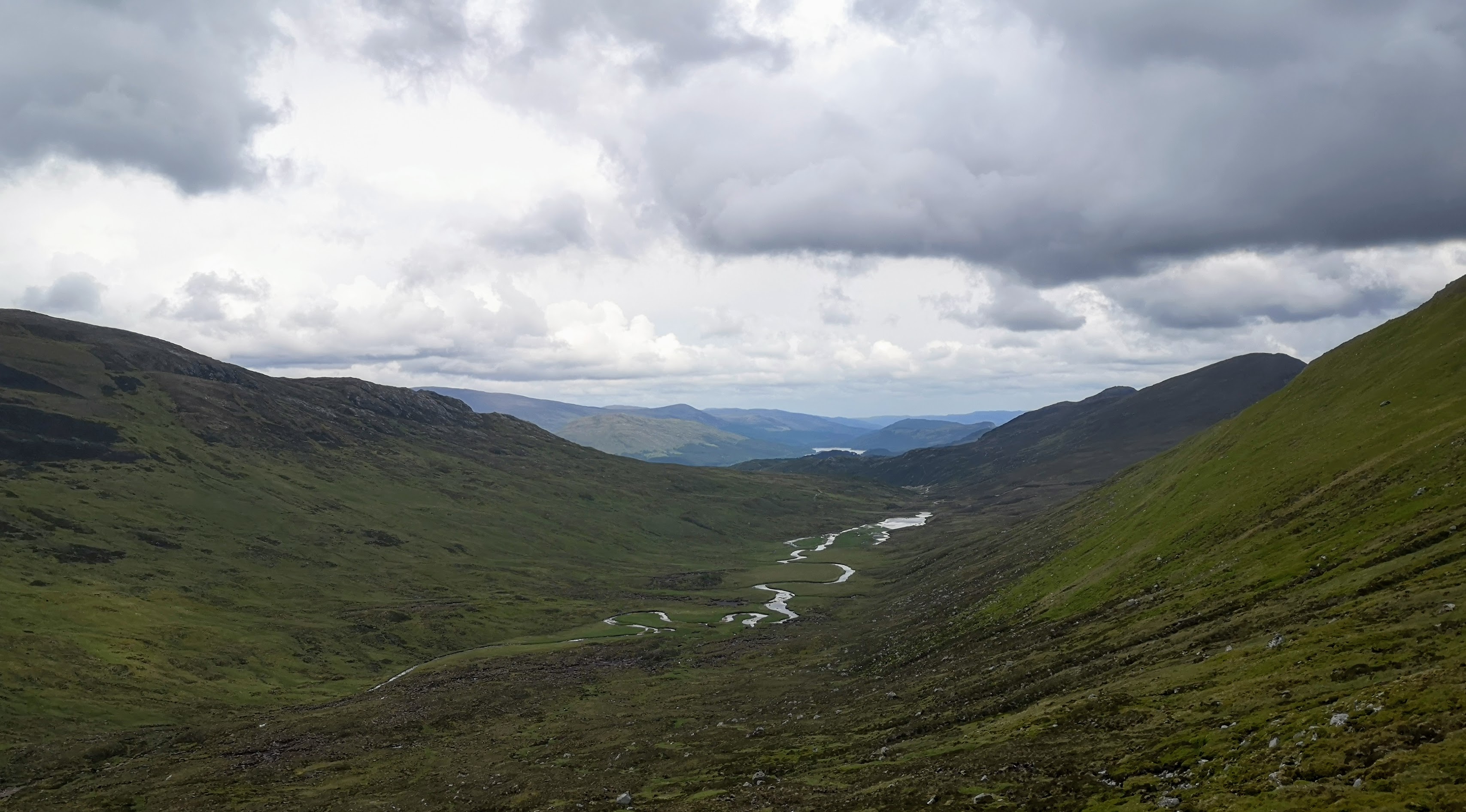
08:48 LOOKING WEST UP GLEN AFFRIC

I deliberately took things slowly as I knew this could well be a bit of a struggle. However fit you are it's worth taking your time as the views opening up are wonderful. You shouldn't really lose the path but you do have to keep your wits about you to locate the double-backs, as animal tracks can lead you astray.

09:08, AFTER ANOTHER SWITCHBACK


09:47, BECOMING A LITTLE HAZY

The path peters out where suggested by the mapping and then there's a fair bit of rough ground and bogs to reach the bealach which has the remnants of a Victorian fence along the ridge. I recall both Phil & I were very relieved to reach this spot last time, and celebrated  by having lunch. 

However this year I was all too aware that I still had quite a long way to go in the afternoon and the clouds were now lifting, so it was going to be a lot warmer. It's 750 feet of a plunging descent at first, to the Allt Garbh below where I would have lunch and fill the water bottles. It's tough on this Softy-Southerner's unfit, untrained knees.

EARLY LUNCH AT THE ALLT GARBH


LOOKING NE DOWN THE ALLT GARBH FROM THE ASCENT OF BEALACH AN AMAIS

Clearly, in the intervening years I had forgotten what a bastard the ascent to Bealach an Amais had been last time. It's a mere six hundred feet of ascent over half a mile, but over the roughest, boulderiest (yes, that's now in the dictionary - well, mine at least) and peat-boggiest ground you can imagine. Foolishly, this time I took a more direct line than that chosen when I planned the route (look up at the map) which meant climbing the bogs by cutting up and across the very steep side of the hill. It was stupid, and stupidly tough going. When I finally made the bealach I was just about all in. 

Cursing myself soundly I sat and took on lots of water, chocolate, jelly babies and cashew nuts as I was well and truly bushed. Anything really, to try and cheer myself up. Giving the map an intense scrute, I established that I had about eight and a half miles to go, most of which would be downhill. It was only 12:30, so the afternoon should be okay. To make life easier, the track up from Gleann Fada had been extended by almost two miles virtually to the top of Bealach an Amais to make the walking that little bit more relaxing.

Now, what was it that Lionel Blue said again?

NOT YET ONE O'CLOCK. THE CIRCLE MARKS THE START OF THE TRACK

The extended track from the bealach was in fact all rather horrid. It comprised lorry-loads of rounded cobbles loosely scattered, broadly resembling a track. From far away it indeed looked like a track. From close up it was an ankle turning nightmare. But hey, it was down hill so as long as I kept my wits about me it'll be fine. As there was lots of time available I sauntered down the glen in a fairly relaxed manner, taking lots of stops for drinks and snacks, determined to decrease the weight of my rather large food bag.

I very quickly exhausted my supplies of water, picked up from the Allt Garbh, when about four miles down the glen, just past the rather nasty Glen Doe Run-of-the-River small hydro works, that now seem to be infesting the Highlands. It was also getting very warm as the clouds had disappeared and the sun blazed down on me. No problem I thought to myself, I'll get some water from the Doe...

Oh no you won't! came the stern reply. Obviously, when permission was granted for the hydro works a condition must have been set to 're-wild' this part of the glen. The river was the other side of a very sturdy, very tall timber and steel wire Berlin Wall. No gates. No stiles. I could hear the water gushing  to my left as I trudged disconsolately down the track, I could almost smell the water, but there was not a drop to drink. And by now it was getting very hot and I was quite thirsty. The streams coming in from the right were all completely dry. 

It really isn't a grand idea to get this thirsty as it's a sign that you're quite dehydrated, and I had Megan's new kidney on board to look after. New kidneys should be looked after, wrapped in cotton wool, loved and cherished. A few beers perhaps, to cheer it up? At my turn-off two or three miles later there's a bridge over the Doe. I'll get down to the river there, I thought.

No. That was behind iron curtains as well. No matter, I'll get some from the very large Allt Bhuruisgidh, I thought cheerily to myself.

Fat chance. I was faced with a very large diameter concrete pipe - part of an old Large Hydro Scheme from the thirties, I would guess, presumably intercepting rivers, starting with the River Doe, to take to a large Hydro Electric Power Station's reservoir miles away. There was absolutely no way I could get to the stream. I had noticed when planning the route that this track I had chosen to follow was beautifully level, I had not realised that it was to service this massive concrete pipe, that was not marked on either the 1:50 or 1:25k maps, that I was now to follow for the rest of the day. 

THE WATCHERS, WAITING TO POUNCE AS I DROP FROM DEHYDRATION...

At every stream interception there were ancillary works that swallowed up the water into the pipe. Some very, very parched two miles later, the ghastly pipe allowed a small amount of the Allt a' Chroinn to run over the track to a little weir to fall into a mini reservoir. The rest it swallowed greedily.

With a little effort I managed to fill my large water container from the inch-deep water running over the track. I reached my camp spot around an unexpectedly late six o'clock, very dehydrated and very very tired indeed. I must have been walking at a snail's pace. Since the Bealach, including stops I had averaged two and a half kilometres an hour - downhill!

LOOKING WESTWARDS AT 6:40 PM. THE PIPE ACTUALLY RAN UNDERGROUND, BENEATH MY SHELTER.

I was so knackered I couldn't be arsed to fire up the stove and cook, so decided instead to finish off the rest of today's snacks and have tomorrow's lunch instead. Lunch tomorrow would be this evening's meal. Oddly I didn't miss having a hot meal at all... Ian definitely has something here.

DAY TWO CAMP SPOT

You will have seen a picture of cattle looking down at me from atop their hill. That was a mile or so back along the track. To the left of my camp-spot photo you can see there's a bit of hay scattered about the ground. The cows came to visit me at about three o'clock in the morning. There was some very loud breathing and grass being ripped by its roots just next to my head. I lurched out of my shelter to shoo them away - I'd heard tales of cows rubbing themselves against a tent thinking it was something solid to have a good scratch against, and promptly flattening the tent. I had had enough of hospitals for a while so I didn't fancy that outcome at all.

Note to Self: Find out if there is any truth in that.

Tomorrow had to be better day, surely?


18 February 2018

Scottish Highland Estates, greed & the loss of wild land

INTENSIVE MUIR BURN ON A GROUSE SHOOTING ESTATE [RIGHT CLICK TO ENLARGE IN A NEW TAB]


Regular visitors to this place will have read the piece posted on here a couple of days ago: Scottish Highland Hydro Scheme Mapping. I provided a link to it on the TGO Challenge Message Board, as these schemes have a direct impact on Challengers who walk across Scotland, particularly so as the majority of these schemes have not yet made it onto Ordnance Survey Maps.

Here's a screen grab of that post on the Message Board, and the first reply from a chap who will be taking part in the Challenge for the first time this year. 

RIGHT-CLICK TO ENLARGE IN A NEW TAB

For those of you with small screens, I'll reproduce Paul's comment at a larger size below:


I've met Paul and I found him to be an intelligent and likeable bloke. I'm sure quite a few other very decent hill walkers will share his view, which is why I'm giving space to it as a separate piece, away from the narrower issue of Small Hydro schemes.

As regular readers will know I am particularly keen to promote the TGO Challenge, especially to first-timers as they are the life blood of the walk. (Mortality is a statistician's delight as without exception everyone dies and the more Challenges you do, the closer you are to meeting your maker.) If we want the TGO Challenge to continue, then fresh blood is vital.

I've walked across Scotland for over twenty years and over that time have seen a dramatic drop in the wild places. The predominant reason for this being the remorseless spread of wind farms (with the associated tracks and electricity pylons) a massive rise in hill roads for the grouse shooting industry and considerable changes, especially in the eastern Highlands in vegetation as muir-burn has become the predominant landscape. Recently Small Hydro (predominantly run of the river schemes) have  spread like a rash throughout the wild places.

Elsewhere on this blog I have written extensively about my despondency of walking through more and more damaged landscapes on the Challenge. (Just click on "Wind Power stations" under the 'Label' heading on the RH column of this blog) As I promote the Challenge a great deal, I think it is time to accentuate what is fabulous about walking across the Highlands and some of the positive changes that are being made by enlightened estate management.

*****

As I understand it, Paul is making two points; The first is that Highland Estate owners have to make a living from their land and the choices are from either small hydro scheme subsidies, wind farm rental, commercial forestry or grouse shooting. His second (supporting) point is that he's all in favour of killing mountain hares to preserve the grouse shooting industry, which in his opinion preserves the land from commercial forestry, as he would prefer to see shooting instead of forestry or wind farms.

He suggests that it is not helpful for me to rail against small hydro, grouse shooting and wind farms, as that leaves only forestry and he would not like to see that marching across the hillsides. In his view trying to limit wind farms, small hydro, grouse shooting and forestry (which I don't believe I have ever mentioned) will lead to the depopulation of the Highlands.

At first pass it might seem that Paul is making a fair point. Indeed, these are the points that Scottish Land & Estates - the representative body of the majority of Estate owners - trot out at regular intervals to support grouse shooting, industrial scale wind farms, hydro schemes and commercial forestry across Scotland. After all, these Estates provide a living for a fair few estate workers across the country.

Let's look at Paul's second, supporting point to start with, as it bolsters the main thrust of his comment.

The points about livelihoods and killing hares (regarding grouse shooting) are made well in the recent BBC Countryfile television programme that Paul made mention of on the TGO Message Board, before he deleted the comment. The programme examines the mass shooting of mountain hares (a native species) to protect the grouse shooting industry. However, the same could also be said of the points made by Harry Huyton of OneKind against the shooting of Mountain Hares. Take a look at the programme  yourself: It's about a ten minute watch. You can see the programme on the BBC iPlayer for the next 16 days by clicking on the following link:


NB: Rather than watch the entire programme, the relevant sections are from 7:00 to 14:00 and 30:30 to 36:10

Harry Huyton's subsequent take on the programme can be found here: Three reflections on Countryfile's mountain hare culls feature 

For a detailed look at hare culls you might like to view this document: Mountain hare persecution in Scotland After reading that, I think you'll agree that Paul's position on culling mountain hares looks pretty shabby.

*****

Now let's take a look at Paul's first, main point: Scottish Estate owners have to make a living, and it's going to come from either grouse shooting, rental income from wind farms, commercial forestry or small hydro.

Of course, this is a straw man argument. Those are a carefully selected sample of possible income streams for Highland Estates. As it happens, they are the income streams that some find unacceptable in the modern world and so we are given a choice by the estates (and Paul) to choose those we find least unpalatable from their selection.

On the morning of the day I posted the link to my piece on Small Hydro Mapping on the Challenge Message Board I had also posted a piece that Chris Townsend had mentioned on twitter - an inspirational piece from the Scottish Wildlife Trust's website written by the Estate owner, Lisbet Rausing, detailing the work that Corrour Estate has been doing over the last ten years or so and the plans it has for the next ten. You can find that piece by clicking on this link:


LOCH OSSIAN AT THE HEART OF CORROUR ESTATE @ JONNY HUGHES


I really would like you to read this piece so that we can understand each other as we move forward. So sit up straight at the back of the class and take a few moments to read it please.

Thank you.

*
*
*

And, you're back in the room! Hello again. That was a great read. You're jolly glad you took some time over it.

You will have seen that the stewardship of Corrour Estate has shifted fundamentally from an extractive model to a stewardship model. The entire ecosystem - flora and fauna - is recovering from over a century of appalling abuse. It appears from this shining example (and others mentioned in the piece) that Highland Estates can make a living without wind farms, grouse shooting and forestry. The Estate now washes its face economically by generating income from tourism attracted to the place by the transformation of the landscape and wildlife.

Who knew?

Tourism is a *major* business in the Highland economy. Visit Scotland estimated that 1,88 million people from the rest of the UK and 0.4 million people from overseas visited the Highlands in 2012/13. These visitors spent a combined total of £509 million.

However, you will have spotted that Corrour *does* include four small hydro projects as part of its income stream - a fairly big disappointment.

*****

This brings me rather neatly to another reason for disagreeing with Paul's comment.

If you or I were to buy our first home, we would know that along with the mortgage and rates that we would have to pay, we would also be faced with a raft of additional costs. Every once in a while all the exterior woodwork would need painting. The decorations inside the place would need keeping in order. Plumbing problems, heating bills, electricity bills, they all need to be sorted.

Moving on to your next, larger house, all those costs increase, and so on to an even more expensive house, with a large garden, fences to maintain, you'll need a larger lawnmower. You can already see where this is going, can't you?

Those fortunate enough to be in a position to buy a Scottish Estate know full well what they are buying. They are buying a whole heap of ongoing outgoings that to you or me would seem eye-watering! Of course, they would try to mitigate these costs by having an income from the Estate. And that is exactly what Lisbet Rausing is doing at Corrour.

But let's not kid ourselves; these Estate owners are incredibly wealthy individuals, from all corners of the world as well as the UK. And let's be brutally honest. They can afford to run an Estate, even when it makes a loss. Their accountants will have told them how much it was going to lose year on year before they bought the place and that was part of the purchase decision, just as I knew full-well when I bought a sixteenth century listed cottage with wattle and daub exterior walls that it was going to be eye-wateringly expensive to heat. There's not a scrap of difference between the two purchases.

*****

Going back to Paul's comment: He says "...what would you like them to use the land for? It has to be used for something..."

I really do have a big problem with that statement alone. I would be quite happy to sit here for a few days debating just that one question and answer. You see, Paul is looking at land as a commodity, or a vehicle to provide an income.  He's not looking at land as something that just by being there provides huge pleasure to those who live amongst it and those who travel through it. These people are not monetising land. I could quote John Muir verbatim about land and wild places. You'll have heard it all before.

However, the land that these Estates have parcelled up between themselves doesn't care who owns it, or who walks though it. It is just there and that is why we hill-walkers go there ourselves. It is for freedom from the daily grind. It's to reduce stress. It's to be like my friend Mick, who I wrote about only this week, HERE.

And we should not forget, that is the main reason the Estate owners bought the place at the very outset. Because to live there would be to fulfil their dream of living in one of the finest places on the planet.

*****

So let's not hear any more about monetising Highland Estates. It's not about the money. It's not about choosing between one, two or three or even four methods of abusing wild land. Those choices are strawmen arguments put up by those who enjoy shooting birds for fun. This argument is put up by those who want to rake in extra money by letting out their land for commercial forestry, or wind farms or building small hydro schemes - each of which is designed, built and paid for by other commercial enterprises.

So Paul, let's not hear anymore about the further depopulation of the Highlands; Corrour has shown that to be complete nonsense.

Let's instead encourage landowners to take a lead from Lisbet Rausing and the incredible work she is doing at Corrour transforming the place from an extractive business model to a stewardship model. And really, Lisbet, there was no need for you to build those small hydro schemes at all. You can afford to live there without them. 

*****

Footnote: Wise and venerable readers of this blog will have noticed that in this entire screed, written all in one mad rush, there is no political message. I haven't mentioned the SNP once, because there's no need to. Greed is the same the world over.

15 February 2018

Scottish Highland Hydro Scheme Mapping

Reading TGO Challengers' accounts of last year's walk across Scotland I was struck by how many Challengers encountered run of the river small hydro schemes, often in places that would otherwise have been described as having a feel of wilderness. To a man, they felt these places had been desecrated

I was aware of the existence of small hydro schemes in the Scottish Highlands as Phil, Andy & I had walked past a few on our Challenge in 2014 prior to our TGO Challenge in 2017. Here's one on the north shore of Loch Quoich. This particular building houses turbines that have a plated capacity of 775kw. (For a recognisable comparison most modern land based wind turbines have a capacity of about four times that amount.) That does not mean it produces 775kw; it's the maximum it can produce. Like wind turbines, run of the river schemes like these are weather dependent. If it doesn't rain for a while the water levels will drop and the power output will be a small fraction of the plated capacity. In a very dry spell it will produce nothing at all.

This means that a lot of work goes in to providing very little power - and variable power at that. These schemes attract heavy renewables subsidies (paid for by you and me in our electricity bills) to make them economic to the developers. Let's be very clear here: They would not be built without these heavy subsidies.

775KW CAPACITY HYDRO SCHEME, LOCH QUOICH


The photograph below shows that VeryVeryNiceMan Mr Williams posing by an access road to the Taodail Small Hydro scheme near Strathcarron - a hour into our walk into the wild places on last year's TGO Challenge.

TAODAIL HYDRO SCHEME ROAD, STRATHCARRON


This was my take on the two schemes we bumped into that year. We were not impressed. Neither of the roads we saw had made it onto O.S. mapping so they were an unpleasant surprise.

  • Surprisingly, we catch up with Croydon, Paddy & Gillian on one of those new Hydro Scheme roads that are currently being blazed throughout the length and breadth of the Highlands, destroying yet more of the wild quality that has been such a magnet for so many years. After a bit of a dither where the new road has obliterated the old stalkers path, we clamber up the side of the cutting and carry on our way, deeper and higher into the hill. 

SCREENSHOT OF HIGHLAND HYDRO SCHEME MAPPING [CLICK TO ENLARGE]

The above map is a screen shot of the Highland Council's map that shows all the hydro schemes that have been either been built, or are under construction, or in planning and also those that have been refused planning in the Highland Council planning area.

If you right click on that map and open it at a much larger size in a new tab you will find the Taodail Hydro project. On the actual Highland Council map, if you were to click on the Taodail little yellow dot the screen shown below appears:

TAODAIL HYDRO SCHEME [CLICK TO ENLARGE]


You'll note that the dot is coloured yellow as at the time of the map's preparation (Jan 2017) the project was under construction. When we discovered it in May 2017 it looked virtually complete. You can get rid of the information tab to reveal all the mapped features of the scheme. See below:

TAG REMOVED TO SEE MORE CLEARLY [CLICK TO ENLARGE]


Here's my take on the second run of the river hydro scheme we bumped into on our way over from Glen Orrin to Glen Strathfarrar, one of the most beautiful glens in the Scottish Highlands:

  • Pleased as punch we positively gambol down the other side on nibbled turf. The first quarter of an hour is fabulous, following a bubbly caochan downhill until it becomes the Neaty Burn proper. Then it all goes to rat-shit for a while with stumbly heavy heather, awkward clambers up and over the burn bluffs. It's still cold and showers are now coming at us from the west down Glen Strathfarrar. It's all quite knackering. 
  • And then we see a big new road, dead ahead, following the burn downhill. 
  • Of course, it's yet another Mini Hydro Power scheme. The actual works themselves are not wildly intrusive, tucked away at the bottom of the little gorges that they are placed within but the roads that enable the schemes to be built and maintained are horribly so. And they're appearing all over the Highlands because there are massive subsidies to be farmed by the already wealthy landowners. The amount of power they produce is minuscule and all at a terrible cost to wild land.
NEATY BURN HYDRO SCHEME


  • The old stalkers path down the Neaty Burn has been obliterated by the new road and so we plod somewhat disconsolately down the dirt road wide enough for two trucks to pass each other. The old path chose a line with gentle gradients. This new road dives straight down the hill which is tough on my dodgy left knee. All the wild qualities of this old route have now gone. We're now on a road, heading down to the new housing for the generators - a modern pitched roof construction, not unlike a large house in appearance, surrounded by a large concrete apron and heavy river pebbles.
  • We sit against the wall for a little shelter from the rain and it's all rather depressing. Dear God. What were they thinking of? They've already screwed huge swathes of Scotland with bloody wind farms and now they're destroying havens of sylvan bliss with houses, concrete and roads. All in the name (and only the name) of supposedly 'green' policies. Had these idiots actually done the maths they would realise they are pissing in the wind and their tokenism is fucking Scotland to the hilt. 
  • Bastards.

The next map is the detail gleaned from the Highland Council mapping. This scheme, which has totally destroyed the wild feel of this wonderful place produces a paltry 700kw (plated, remember, so a great deal less on average, and intermittent) of electricity at a massive cost to the environment.

ZOOMED VIEW WITH DETAILS OF THE 700KW NEATY BURN HYDRO SCHEME [CLICK TO ENLARGE]


With this mapping from Highland Council it is now possible to plot these Hydro Schemes on your own maps (a lot of Challengers print out their maps) so that you know when out on the hill where they are and can choose to avoid them.

The Highland Council maps can be found by clicking on the link below.  Have a play with them. Blow them up. I believe you'l be very surprised at just how many of these schemes there are and the crass insensitivity of their locations.

Scottish Highland Hydro Scheme Mapping

Comments are welcome: